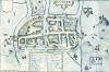
 Limericke 1610
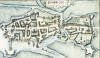
|
[Back] |
[Preface] [Contents] [Bernards] [Index] [Depositions] [Maps] [Definitions] [Town/Parish Descriptions, 1835] [Pictures] | ||||||||||||||||||||||||
|
Chapters |
01 | 02 | 03 | 04 | 05 | 06 | 07 | 08 | 09 | 10 | 11 | 12 | 13 | 14 | 15 | 16 | 17 | 18 | 19 | 20 | 21 | 22 | 23 | 24 | 25 |
Maps with respect to the "History of Bandon"
click on picture to see larger image and notes
Cork City 1610 Limericke 1610
Bandon 1613 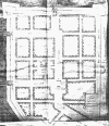 Bandon 1620
 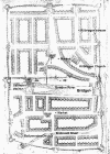 Bandon 1775
 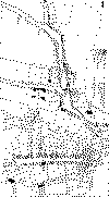 (north orientation)
Bandon area c.1675  Bandon area c. 1750
The following 4 maps will take about 1 minute to load using a modem:
Large Map North West Ireland c.1690  Large Map North East Ireland c.1690
Large Map South West Ireland c.1690  Large Map South East Ireland c.1690
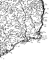
Ballyneen; 19th Century Ordinance Survey 
Enniskeane;19th Century Oridinance Survey 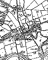
Bandon Bridge Walls  (surviving and suggestions)
Ballineen and Enniskeen Area 19th Century Survey  Very large file!!!!!
Cork/Bandon - 1980 road map  large file
Bandon and South - zoom 1980 road map 
Bantry - Skibbereen area 1980 road map 
|
[Back] |
[Preface] [Contents] [Bernards] [Index] [Depositions] [Maps] [Definitions] [Town/Parish Descriptions, 1835] [Pictures] | ||||||||||||||||||||||||
|
Chapters |
01 | 02 | 03 | 04 | 05 | 06 | 07 | 08 | 09 | 10 | 11 | 12 | 13 | 14 | 15 | 16 | 17 | 18 | 19 | 20 | 21 | 22 | 23 | 24 | 25 |